วันเสาร์ที่ 18 ธันวาคม พ.ศ. 2553

Recommended Free Apps on iOS devices

Good Free Apps on iOS for Map Users

1. Avenza PDF Maps by Avenza Systems Inc.
Recent added features allows PDF Maps users to download USA topo maps for offline use.


2. ArcGIS for iOS by ESRI
Users can access services from ArcGIS server on iOS devices with this app. Member of ArcGIS Online who have created his/her maps or applications using ArcGIS Online can access his/her work with this application on iPhone/iPad.


Both softwares are available free on the iTune App Store.

กรมที่ดินให้บริการสอบถามข้อมูลแปลงที่ดินผ่านระบบอินเทอร์เน็ต


กรมที่ดินให้บริการสอบถามข้อมูลแปลงที่ดินผ่านระบบอินเทอร์เน็ตแล้ว ก่อนหน้านี้ได้ทดสอบระบบตั้งแต่วันที่ 1 กันยายน 2553 บริการนี้จัดให้ประชาชนที่ต้องการสอบถามข้อมูลตำแหน่งที่ตั้งของแปลงที่ดินโดยใช้เว็บบราวเซอร์ สามารถใช้บริการได้ตลอดเวลา โครงการนี้กรมที่ดินใช้บริการแผนที่ออนไลน์ของ Google (แผนที่ฐานและ API) เป็นเครื่องมือพัฒนาต่อยอด ในขณะนี้สามารถให้บริการครอบคลุมพื้นที่ในความรับผิดชอบของสำนักงานที่ดิน 46 แห่ง ประชาชนสามารถค้นหาตำแหน่งที่ตั้งของโฉนดที่ดิน ตำแหน่งที่ตั้งของแปลงที่ดิน และสามารถใช้บริการแผนที่ซึ่งกูเกิลจัดให้อยู่แล้วได้ตามปกติ เช่น การหาเส้นทางจากสถานที่แห่งหนึ่งไปยังที่ตั้งของแปลงที่ดิน

ขั้นตอนการใช้งานมีดังนี้
1. เข้าสู่เว็บไซต์ของกรมที่ดิน http://dolwms.dol.go.th
2. เลือกจังหวัด อำเภอ กรอกเลขที่โฉนดที่ดิน แล้วคลิก "ค้นหา"
3. คลิกเลือกแสดงข้อมูลการเดินทาง จากที่นี่ไปยังสำนักงานที่ดินเพื่อขอเส้นทาง
4. ถ้าต้องการค้นหาเส้นทางจากสถานที่อื่นเพื่อไปยังตำแหน่งแปลงที่ดิน ให้กรอกสถานที่นั้น แล้วคลิก "ค้นหา"

ผลการใช้งาน มีปัญหามากเมื่อใช้ Firefox (บน Ubuntu Linux) เลือกจังหวัด อำเภอไม่ได้ และพบว่ามีหมายเหตุ "เว็บไซต์นี้เหมาะสำหรับ IE7 ขึ้นไป" แสดงว่าผู้พัฒนาซอฟต์แวร์ยังจมปลักอยู่กับการใช้ซอฟต์แวร์ตระกูลวินโดวส์ และไม่แก้ปัญหา Cross-browser ให้ผู้ใช้ browser ตัวอื่นที่สำคัญได้ใช้งานได้ด้วย


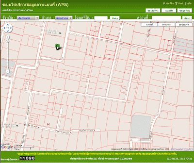
ตัวอย่างในรูปข้างบนเป็นบริเวณซอยสุขุมวิท 31 ค่อนไปทางทิศเหนือ ซึ่งเป็นเส้นทางลัดสำหรับรถที่มาจากถนนสุขุมวิทไปออกถนนเพชรบุรี บ้านบุคคลสำคัญหลายคนอยู่ในซอยนี้ เส้นสีแดงแสดงแปลงที่ดิน เป็นชั้นข้อมูลของกรมที่ดินวางทับบนแผนที่ฐาน(ถนน)ของกูเกิล

วันศุกร์ที่ 28 พฤษภาคม พ.ศ. 2553

Google Earth v5 gives you access to the past

Google Earth v5 has new features that gives you access to the past. I have used it to view the areas around Banda Aceh, Indonesia where the great tsunami (Dec 26, 2004) hit hardest. The images below are of June 23, 2004 (6 month before the disaster); Jan 28 (1 month after), 2005; and Feb 23, 2009 (recent image). As a matter of fact, Google Earth always and will always show you the past. But now it can show you images from several epochs of time in the past.
Six month before the tsunami

One month after

Recent image

วันพุธที่ 3 มีนาคม พ.ศ. 2553

I am a Linux User and its Advocate


I have been interested in Linux for many years. Eight years ago, I gave it a first try on my old PC when it was phased out for the place of newer and more powerful one. Installing Linux was a daunting task in those days, after a few installation failures, I gave up and realized that it was not ready for me yet. Two years ago I gave it another try with Ubuntu 8.10 on my out-of-date PCs. This time it was a breeze, I succeeded in installing Ubuntu Linux on those machines on the first try. During the past two years of my regular use of Linux (on both old and new computers, single and dual boot OS), I helped and urged many people to use it with some success. Today I have just registered as Linux user #506201 with the Linux Counter.
Ubuntu: For Desktops, Servers, Netbooks and in the cloud
Useful links: Linux advocacy how-to | FOSS advocacy